If you were to ask me about the very best outdoor week in my life, I wouldn’t hesitate a long time. It was this week.
I spend a few hours in Tasiusaq to have a wash (which is possible for visitors in the tiny school), pick up my post package with supplies for the next 10 days, and have a phone call home with the cheap public phone in the Pilersuisoq supermarket. I also call Niels from the tourist office in Nanortalik to tell him I’m doing fine.
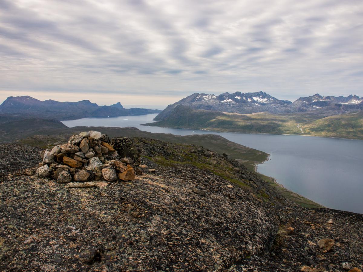
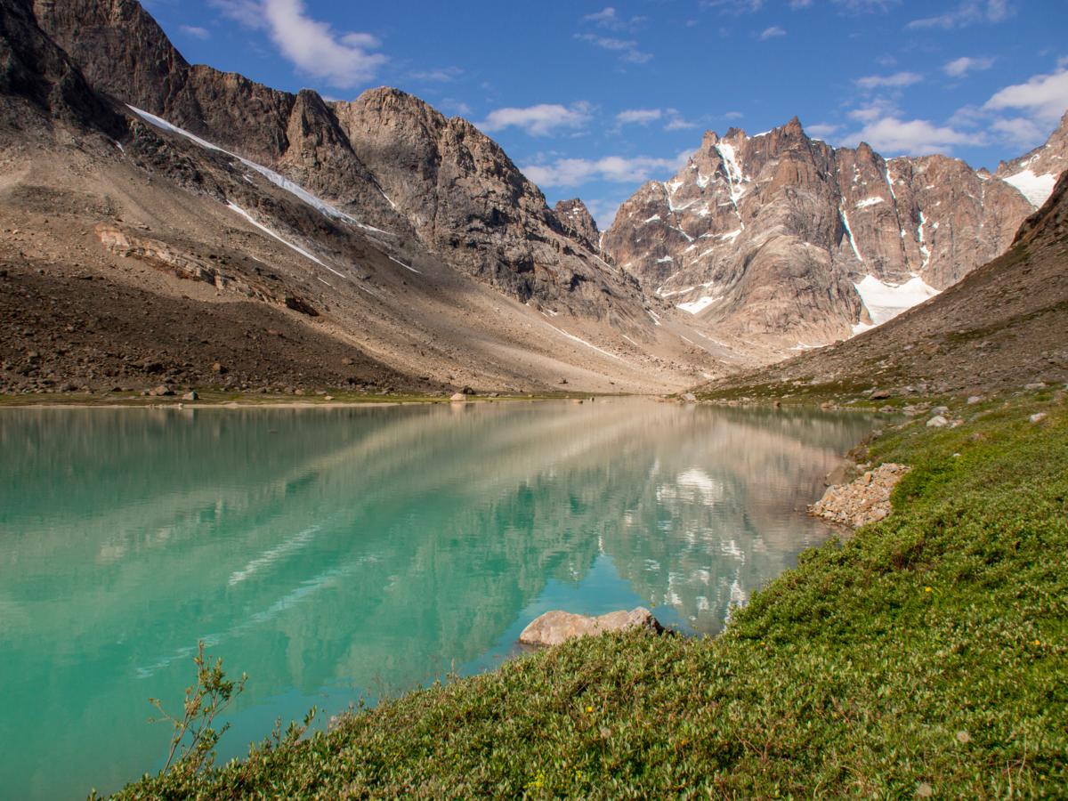
It has become overcast again when I leave the village in the late afternoon and hike back north on the farm track, and climb onto the ridge separating the Tasiusaq bay and Tasermiut fjord, while trying to forget the 10 additional kilos in my pack. I pick a bivouac spot near the lake on the south ridge of the Qaqqatsiaq hill, and hike up a bit higher in the evening to enjoy the views south down the fjord all the way towards the Atlantic, and east towards the wild mountain ranges around the Qinguadalen and Qingeq kujatdleqdalen, at the tip of the Tasersuaq lake.

It is still overcast and calm weather the next morning as I track the south ridge all the way up to the summit of Qaqqatsiaq. Apart from a short scramble on the last push towards the top, it’s a technically easy climb on tundra terrain. But, still not fully adapted to my heavy pack again, the long climb costs me a lot of energy.
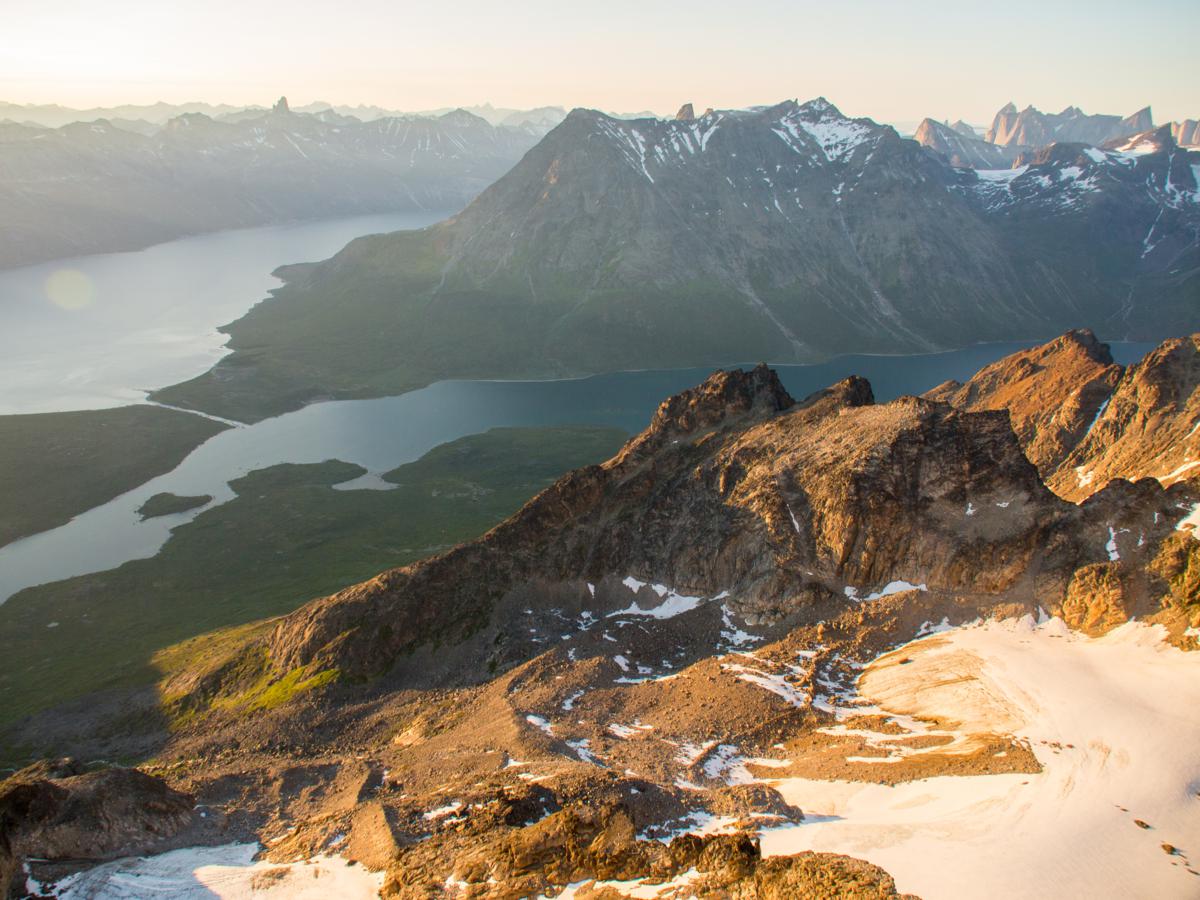
The views are once again highly rewarding, however: I can see the mountains lining the western side of the fjord all the way to the ice sheet, and follow the fjord down to the ocean. But the most impressive is no doubt the Tasersuaq lake, its western half dotted with islands, and engurdled by the wildest of mountains. The southern shore is an endless skein of high bushes, which I want to avoid at all cost by packrafting the length of the lake. The water is flat like a mirror, and I start the descent with good moods. The terrain is very steep at first, but once below 300m the gradient starts to ease while the amount of bushwhacking increases, becoming very nasty when I have almost made it down. I put on my head net again to ward of thousands of hungry mosquitos and small flies.

As soon as I’m on the lake, the wind starts to pick up. It is a strong fjord wind from the northwest, thus afflicting me from the left. I have to fight not to be blown onto the lee shore, but finally manage to battle towards the main basin of the lake, where I turn east and get the wind almost in my back.
But the weather Gods won’t let me get across the lake so easily. A fascinating fight between the fjord wind and a wind from the east is taking place, and I’m just a helpless toy somewhere in the middle. The fjord wind, maybe wind force 3 or 4, is sweeping across the lake from the northwest up to the large island almost in the middle of the main basin. Further east, a 4 to 5 beaufort easterly wind propels breaking waves from east to west. Splashy and chaotic interference waves mark the convergence zone between the two. There is no way I can paddle against the easterly wind, and near the large island it looks as if I will have to pack my raft, and continue walking along the shore, with the worst of the bushwhacking still ahead.
I take a break before I desinflate my raft, and notice the convergence zone is slowly moving east, with the northwesterly to westerly fjord wind gaining ground. I decide to start paddling again, more or less at the same pace of the moving convergence zone. I manage to round the peninsula about 4km from the eastern tip of the lake, before I am finally halted by the easterly wind again, now a wind force 5 to 6 breeze funneled by the narrowing valley. Luckily, I have already paddled past the worst of the bushwhacking and boulders along the shore. The remainder of the walk towards the eastern tip of the lake is fairly easy, mostly on pebble beaches, with only a few short bushwhacking sections in between.


At around 5 o’clock in the afternoon I reach the debouchment of the river coming down from the Qingeq kujadleq valley into the lake. Towards the north, the view through the Qinguadalen, the valley hosting the only real ‘forest’ in Greenland, is stunning. The mountains rise up almost 2000m right from the base of the valley. I had planned to pay a short visit to the valley by paddling across the lake, but the strong wind thwarts my plans. I pitch my Cricket Tent behind a few birches to get some shelter – and a good rest.

It rains during the second part of the night and the entire following morning. Around noon it finally becomes dry again, and by one o’clock in the afternoon I hit the trail again. The cloud base remains low at just 600-700m. During the first part of the day I slowly hike up the Qingeq kujatdleq valley, with many stretches with infamous bushwhacking. The terrain becomes easier as I climb along a waterfall towards a second part of the valley, with the stream coming down from the glaciers high on the southern slopes meandering through.

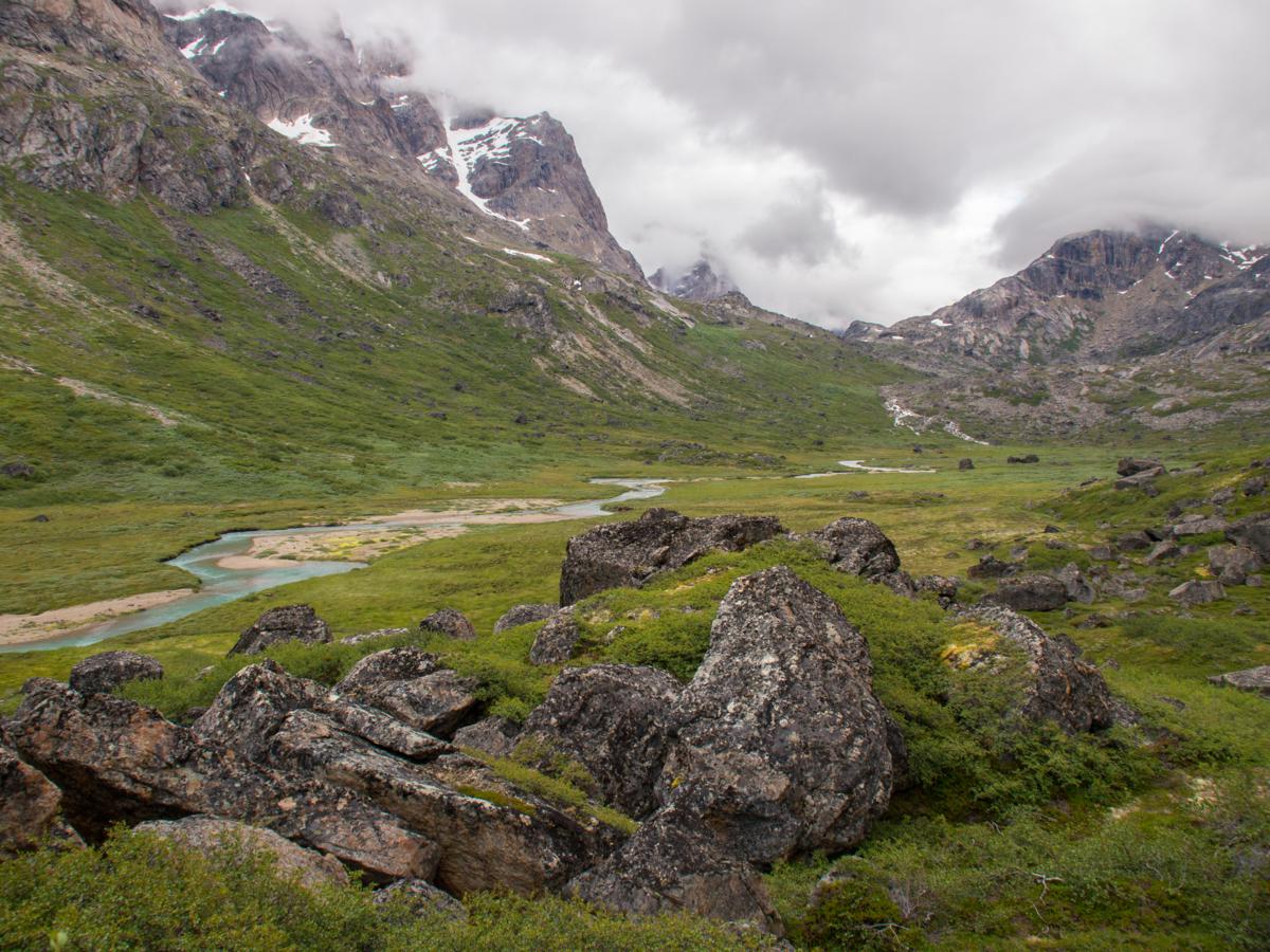
I have to cross the river to continue further towards the pass which will allow me to start my descent towards Kangerdluk fjord. But, being pregnant with meltwater and runoff after a wet night and morning, that is not as easy as it sounds. The river is way too deep in the meandering part, and too powerful where it cascades down a single channel. I cross two side streams, then decide to attempt crossing to the left of a boulderfield, where it rushes down through 4 separate channels on boulders and rock slabs. It takes me almost a quarter an hour, but finally I find a way to the other side. As I continue climbing higher into the valley, I note a stretch a bit higher up where the entire stream is covered by big boulders, thus making it possible to avoid fording altogether.

The crossing of the pass itself is on easy boulderfields, and the terrain quickly eases again as I descend to a plain at the lower end of a glacier. The climate clearly gets colder as I hike east towards Kangerdluk fjord, as I do not encounter any shrub all the way down through the valley towards the fjord. It is a cold afternoon, and the westerly wind nearly blows me out of my clothes. The strongest gusts reach speeds of about 100km/h. As I reach the eastern end of a braided part of the river, just before it steeply plunges down towards the head of the fjord, I start looking for a sheltered bivouac spot, which I eventually find behind a huge boulder.
I have a though evening mentally. I know the landscapes I am hiking through the most wonderful in my life, and I know the next 2 or 3 days should be the most impressive of the entire trip, with the possibility to climb a few summits. But the weather has not allowed me to ‘play’ in and with the wilderness as I would have liked the past week, and I start to have a negative feeling that it will remain like that for the last part of the trip. It is a miserable night with the wind howling around the boulder and my tarp.

By the next morning, the weather has changed.
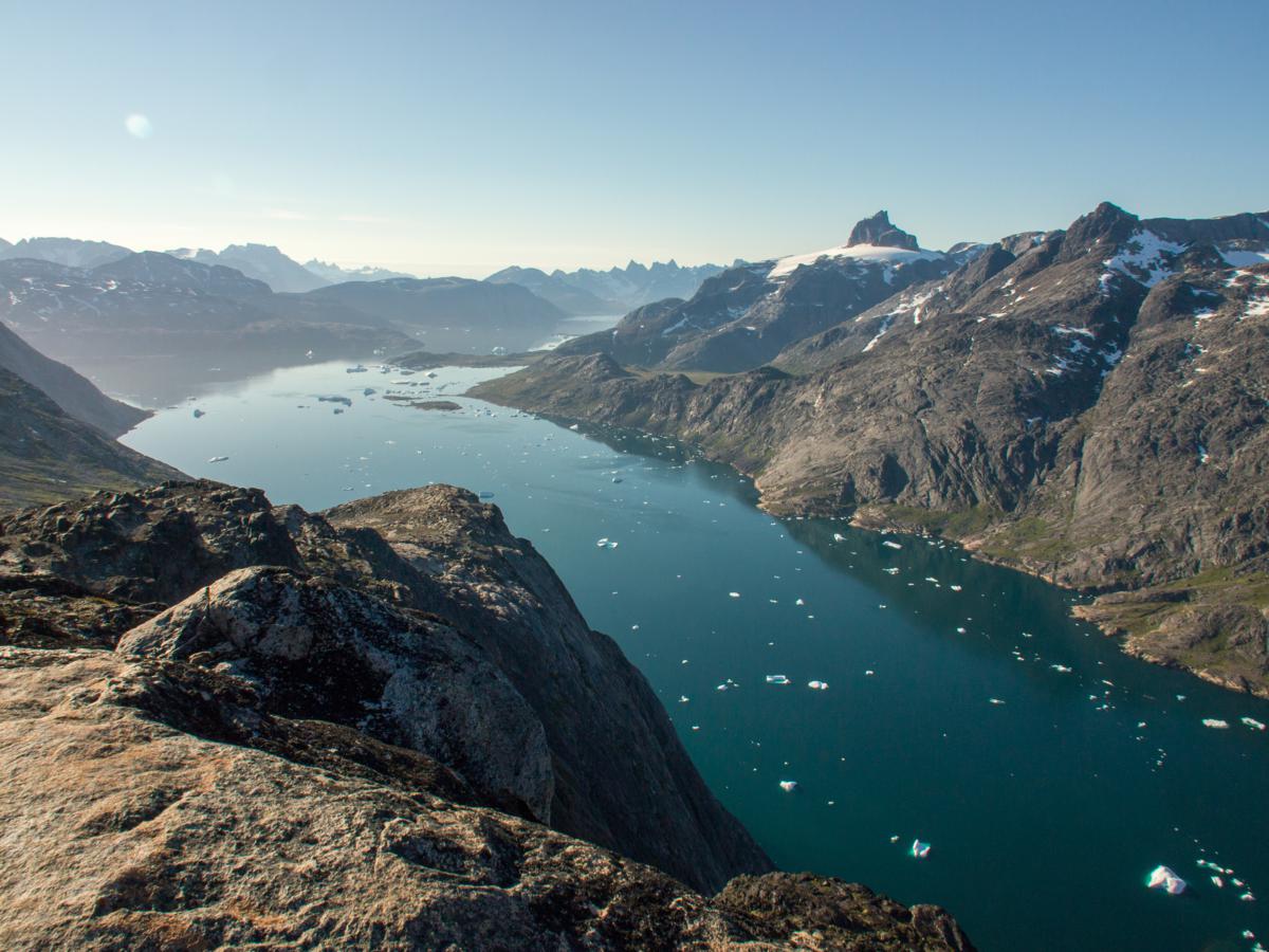
The wind drops quickly, and the clouds break at an impressive speed. The fjord, dotted with massive icebergs and surrounded by huge mountain faces, glisters down in the east. It is almost low tide, and a wonderful delta has formed at the debouchment of the river coming down for a quickly retreating glacier in the north, which has left an ridiculously perfect arch of huge granite boulders behind as a terminal moraine. I walk back a bit to the braided part of the river for the views back through the valley, with the summits of the mountains, draped with numerous small glaciers, now devoid of clouds.

I quickly pack my stuff and descend towards the fjord, which I follow for a short while. I decide to climb the small, nameless summit (969m) on the ridge separating Kangerdluk fjord and the Ivssortussut valley, which I will walk tomorrow. The first part of the climb is a steep, but relatively easy climb on tundra terrain next to a stream with multiple waterfalls. From about 450m, I climb up on scree and small boulders, with one very steep section through a narrow, scree-infested couloir with some easy scrambling to get out again. On small boulders and snowfields with an easing gradient I continue until I reach the ridge at an altitude of about 900m. I continue climbing on the easy ridge towards the summit.
The views are sensational. Towards the east, a labyrinth of iceberg-dotted fjords, sea straits and rugged peninsulas and islands unfolds as I now look deep into Cape Farewell Country. I can look right through Prins Christian Sound, the most popular passage of Southern Greenland for cruise ships. In the north and the west, jagged and nameless brown-grey granite spires with countless glaciers make up for an almost frightening view. Deep, deep down in the south, the green Ivssortussut valley, with a turquoise lake high in the valley, and a snaking valley further down, looks very inviting for tomorrow.


After all the cold, rainy and windy weather of the last week, I feel marveled and relieved at the same time on this summit, and I just feel it is the start of something exceptional.
After carefully descending almost 1000m back to the fjord, I continue following the fjord towards the east, often walking on intertidal beaches covered with small, stranded icebergs. It is a gorgeous afternoon with magnificent light, and I take my time observing the dynamics of the icebergs, the numerous flowers dancing in the wind, and even collecting some mussels I will add to my dinner. I eventually call it a day near the mouth of the river coming down from Ivssortussut. It is hard to pick a bivouac spot, as I could choose a hundred location which are simply perfect. Nature keeps another surprise for sunset when alpenglow floods the mountains at the other side of the fjord, and the low evening sun sets fire to the sky, with icebergs serenely and tirelessly drifting by, carried by the tidal currents. It is hard to describe the feeling of freedom and strength, but also vulnerability rushing through my mind and body at this insanely beautiful place in the wilderness. I has been a day out of a thousand, and that evening I know I will come to Greenland again.


It is still warm and sunny when I wake up the following morning, the perfect conditions for the second high mountain crossing of the trip, over a nameless pass towards the fjord of Stordalens Havn. I have no clue about how steep things will get, and whether I will be able to make it across safely without ice axe and crampons.
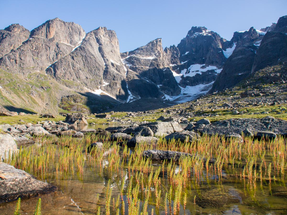
I walk up through the fairytale Ivssortussut valley on fairly easy terrain until I reach the turquoise lake, which I have seen from the summit yesterday, at an altitude of about 300m. Bug pressure is high again today, and I walk most of the distance with my headnet until I reach the mineral landscape when I approach a second lake at 450m, now mostly fighting my way through infamous boulderfields. I start hiking along the western shore of the lake on an alternation of boulders, rock slabs and steep scree. Progress is slow and hard, and I almost get fried by the intense sun. There is no wind at all, and in this natural, mineral kettle temperatures reach about 20 degrees. Sweat drips from my face and arms.


After three quarters an hour I have finally covered the one kilometer along the lake, and I decide to take a long break before I continue climbing towards the pass south of the lake, trying to drink over a litre of water. The climb up is entirely on scree, boulders, snowfields and rock slabs, but remains fairly easy throughout and it doesn’t take me too long to reach the pass (740m).
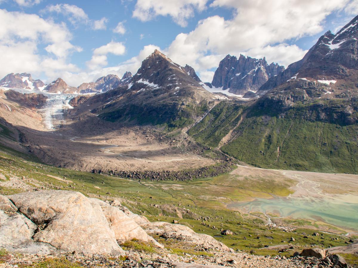
This pass is very broad, and I aim for the easternmost bit to end up near what I presume to be the easiest descent route on the southern side. What I see from the pass confirms what I in fact already knew: the only thing I can see on the other side are a lake, still partly covered with ice floes, surrounded by massive boulderfields, and a mix of boulderfields, moraines and steep rock slabs further down. In the back, the jagged peaks of the Pamialluk island appear for the first time.


I descend from the pass towards the lake on scree and snowfields (about 25-30°). By the way, it looked impossible to me to descend from the western or central part of the pass, which drop down to the lake with very steep rock slabs (45-60°), so you really have to aim for the eastern bit. Once I have made it down, I start skirting around the lake on the worst boulderfields I have battled through in my entire life (with the possible exception of the higher Vallée de Mourguillou in the eastern Pyrenees on a rainy august morning in 2007). The traverse I have to make along the lake is steep (40-45° on certain spots), and many boulders are unstable. At a speed of well below 1km/h I stuggle on until I reach the southern tip of the lake, and somewhat easier terrain. An alternation of boulders, scree and squishy moraine guides me along the snout of a crevassed glacier diving down from the west face of Issuttussoq (1457m).


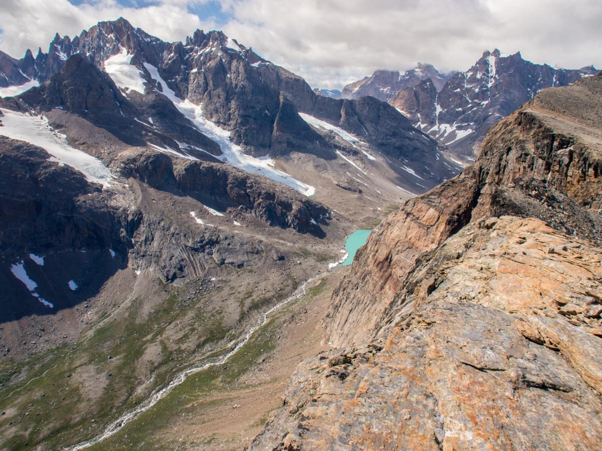
Below the glacier, an icy, sediment-loaden stream snakes down through moraine and outwash. I ford it, then start climbing up a slope of scree and rock slabs to reach the NE-SW oriented ridge leading to a small, nameless knoll (680m), towering high above the Aappilattup avanna sea strait. I have been on the trail for over 8 hours of harsh terrain, and feel the fatigue kicking in badly. But this panoramic spot, almost unnoticeable on a map, is the place I had been aiming for, not only today, but also during the 4 years I had been dreaming to make this trip after reading the report of Joery Truyen. The panorama starts to open up dramatically as I track the ridge towards the knoll.
When I finally get there, I gasp for breath. This panorama from this spot is no doubt the most utterly amazing and wild mountain scenery I have seen in my entire life. I cannot think of any words adequate enough to describe the raw splendor of the landscape. It is simply heaven on earth. Countless iceberg sail through the sea straits of Aappilattup avanna and Torsukattak, which are lined by an incredible big wall of well over 1000m high, and complex mountain ranges with numerous, towering granite spires and small glaciers. Towards the west, I can look through the Itillersuaq valley all the way to the mountains at the western side of Tasermiut. The mighty tower of Tuvilissuaq (1838m) proudly guards the entrance to the valley.


It is a warm, calm and sunny evening and I just sit, watch and marvel in t-shirt for hours, while preparing a 3-course dinner. The light only gets better as the evening slides by. The weather is so nice I decide to sleep under the stars. With clear skies, I assume it will cool down quickly once the sun is gone, and the lower temperatures will keep the mosquitos grounded. I soon fall asleep.
After about 2 hours, with the last hints of twilight still visible through the Itillersuaq valley low on the western horizon, I wake up with a weird, tingling sensation on my tongue and palate. It feel like anesthesia at the dentists. I have fallen asleep with my mouth wide open, and apparently it did not cool down to much this evening as mosquitos have feasted on the tasty flesh on the inside of my mouth! I put on my head net and continue sleeping, and by the next morning the itching is gone.


With the sunlight now coming from the other side, the views are completely different again. It is hard to say goodbye to a spot like this one, and it is around noon when I finally start the descent back into the valley with the glacier I have climbed out of yesterday. The weather remains unchanged, with glorious sunshine and high temperatures which allow to hike in t-shirt all day. I easily track the stream down to an edge at about 380m, where it start to plunge down steeply to Stordalens havn. This is the last part of the trip I did not know what to expect while planning the trip. I ford the powerful stream, and hike further away from it to avoid a series of very steep rock slabs, fording a smaller second stream on the way. The descend is very steep at times (up to 45°), especially at the 100-300m interval, but the overview is always good and it is not hard to pick the best way down on relatively easy tundra terrain, thus avoiding the rock slabs.

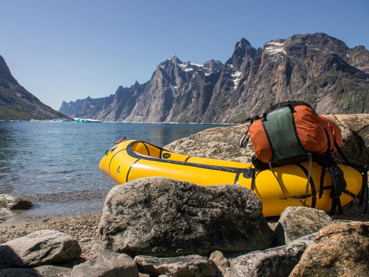
After a while I have made it safely down to the fjord. It is possible to traverse the slopes all the way towards the Itillersuaq valley, but the terrain is steeper and harder than I had expected and I soon decide to just inflate my raft and paddle the 3km distance, between icebergs with the most wonderful shapes, and with the massive granite wall at the western side of the Torsukattak strait as a backdrop. What a scenery!

I paddle on towards the northern branch of Stordalens Havn, a very shallow fjord emptying almost entirely at low tide. After packing my raft, I start hiking into the Itillersuaq valley on very easy tundra terrain with even a fairly clear sheep track, the first signs of civilization again on the approach of Tasiusaq. On the way, I unintentionally scare away a snow grouse with 3 chicks, all flying away in different directions. I hope they found their mom back again.
I take it easy after the long day of yesterday, and soon ford the river to reach a small pond in the valley of the glacier coming down from the northeastern slopes of Alleruusakasit (1708m), which I have noticed from the summit yesterday evening. It turns out to be a perfect place for a bivouac, and I have a quick but full wash in the warm evening sun while trying to get as little mosquito stings as possible. It is yet another glorious evening and I make an walk in the surroundings of my camp to absorb the intimate beauty of the Hippuris vulgaris plants of the pond, the glacial meltwater sliding down through the green valley, and the mightly southwest face of Tuvilissuaq (1838m) which baths in the evening sun high above.


During the night I wake up a few times because of rockfall events higher in the cirque, one as loud as a cannon blast as an apparently very large chunk of rock tumbles down into the valley. When I wake up in the morning by the scorching sun, I immediately decide to make another long day to get the very maximum out of it. I start hiking west through the valley, the easiest bit of the entire trip, yet through an impressive landscape with more towering granite peaks everywhere around.


As I reach the western end of the valley in the early afternoon, the scenery starts to change dramatically. The alpine mountains disappear altogether further west to make way for the rolling hills and tundra around the lower Tasermiut fjord. I won’t hike that far today, however, and decide to climb the northern valley slopes and make another splendid bivouac on a small plateau at about 470m on the southern slopes of Putooruttoq.

I have dinner early, and at around 5 o’clock in the afternoon I start the long climb towards the summit of a nameless mountain (1420m) southwest of the main summit of Putooruttoq (1519m), on (large) boulders nearly all the way up to the top. I have taken only 1 litre of water, and have to temporize and take breaks a few times in order not to start sweating excessively. It must be around 20 degrees again, without even the tiniest bit of wind. At a quarter to seven I finally reach the summit, which is also the highest point of the entire trip.
Once more, the views are outstanding. I can see almost everything I have been hiking and rafting through for the past 10 days: the ice sheet at the head of Tasermiut fjord, the immense big walls at the eastern side of Tasermiut, including Ketil (2003m), the summit at the western side of the fjord I have climbed on this cold and windy evening, the sheep farms around the Qaqqatsiaq hill near Tasiusaq, the Tasersuaq lake, surrounded by highly alpine mountain ranges, and the Itillersuaq valley I have walked through earlier today. In the southwest, I can watch through Tasermiut fjord all the way down to the ocean, with numerous huge icerbergs drifting between the island at the Atlantic coast. Although not as dramatic as those of the previous days, it is probably the most complete and varied panorama of the trip.


It is almost a thousand meters down back to my camp on demanding terrain, but the temptation to stay on the summit until sunset is too big, and I just relax, and absorb the beauty of another silent Greenlandic evening until the sun dips below the horizon at around 9.30pm. I estimate I have about 1 hour to make it all the way down before it gets too dark, and start descending through the boulders, running on the easier bits. After exactly 64 minutes I reach my familiar yellow shelter, and still plain awake with adrenaline I cook some soup before going to sleep.
The next morning I sleep long, and after I notice how stiff my thighs are after yesterday’s dive, I decide to make a short day and just hike and raft 7km towards the town of Tasiusaq, descending towards the Tasiusaq bay first and then paddling across while fighting against a good headwind. With a big smile I enter the town again, and buy some cheese and yoghurt in the shop while trying not to worry about the prices. I take a shower again in the tiny school, and then hike up to the hill overlooking the 79-people town to camp. In the evening I just observe the town, and try to grab what it must be to live in such an isolated yet beautiful place.
I have been on the trail for 22 days now. I have 3 days left, which were in fact my spare days before starting the trip. The past three weeks have already been more than successful. To finish the job, I decide to hike and raft on for a few more days towards the town of Nanortalik, on the Atlantic coast.


Prachtig! Hier hoop ik me toch ook ooit eens naartoe te trekken!
Merci Kasper! Zeker ooit eens doen 😉
“Prachtig! Hier hoop ik me toch ook ooit eens naartoe te trekken!”
+1
Willem, superb trip AND superb writing.
Per usual, I created a thread on BPL (Post trip reports)
Cheers Wim! I had already noticed I get quite some visitors from BPL. Thanks for the publicity 🙂
Fantastisch filmpje en leuke muziek (van welke band?) !
Hey Kenneth, merci voor het kijken/lezen. Muziek is van Phantogram, titel nummer ‘Mouthful of Diamonds’. De inspiratie heb ik gehaald uit deze video van Roman Dial: http://www.youtube.com/watch?v=9bx3PDau6oY
Dat filmpje heeft me destijds min of meer over de streep getrokken om in een packraft te investeren!
Wonderful report! Great pictures and nicely written! Curious as to what heat source is used by inhabitants in areas such as Tasiusaq?
Hi George, glad you enjoy the reading. I apologize for any incorrect english 😉
Good question about the heating, but unfortunately I cannot give you a real answer. In the school building there was an electric heater. Maybe someone else knows more about this?
Hello Willem, I just want to have a advice about your tent. I’m about to buy a MLD and want to know why you choose a Cricket insted a Trail star or Little Star. Is the cricket perfoming well in high wind?
Thanks for you answer and I’l waiting for your New Zealand trip report
Hi Mathieu, thanks for your reply!
I’ve long been planning on an MLD review, but never seem to find the time 🙂 This is what I’ve been writing on the MLD Facebook page a couple of weeks ago:
Overall, I’ve been very happy with my shelter. Just love the overall configuration, spacious enough and a great view of the world from inside. Never had issues with rain being blown onto me from the front. But… as with any piece of gear you have to take into consideration it’s downsides as well. There are better shelters to bivy in high-wind environments. I’ve had wind gusts of up to 100km/h in it and it will hold, but in such conditions (and even a bit less) the Cricket is ballooning all over and you won’t have a good night. I nowadays always pitch it high, with a pole length of about 140-142cm and the pole gently inclined with the top facing backwards. In my opinion the pitch is never as nice and tight in any other configuration, and even with a very low pitch it will be more vulnerable to the wind than with a descent high pitch (given the wind is coming from behind or from the side).
Hi Willem,
first of all let me tell you how absolutely beautiful your photos from this trip are and how exciting everything sounds. Thank you so much for sharing!
I will go to South Greenland in August and we were planning on doing some multiple day hike around the Tasermiut Fjord. However, we were not sure yet what route exactly. Your trip looks so good and I have some questions about it which I would really appreciate you answering.
1. It looks like you were hiking along the Kangerdluk Fjord. Where exactly did you start and where did you end?
2. Did you start at the Tupaasat valley and then headed south or the other way around?
3. And did you follow any particular trek/trail or did you just hike along the mountains there? Is this even possible?
4. And, the most important question, where exactly do I need to go in order to get there: https://willemvandoorne.files.wordpress.com/2014/01/p7280934-716_1200x900.jpg ? It looks absolutely breathtaking and I have seen some photos from spots like these but I find it so hard to find out where exactly to go, what mountain to climb and how difficult it is to get there.
I have read your travel blog but I still find it hard to reconstruct your route and how to get there, which is why I would really appreciate if you could answer me some of the above questions if you find the time. That would be such a big help organizing this trip which I want to be extraordinary but which is so hard to organize due to the lack on information of many places there.. 🙂
Thank you so much, and once again, wonderful job with the photos and video,
Nicola